The second problem I met was after the first stage of the process (I met per second because I realise it following the steps described in the other chapters): We should find a model to organise the world so it could be compatible with the game scenario.
United Nations and World Bank are using their own models (UN link, WB link)
Even if World Bank has a very good model, there are some decisions I really don’t like: for example North Africa with Middle East, Indocine separated from South Asia, East Asia together with Pacific, Europe with central Asia … So I decided I had to identify my areas, and I want to introduce one key principle:
- Areas should be as much as possible based on common knowledge of the world
Given above principles the real problem was related to Pacific (Australia, New Zealand …) and Russia.
As you can see from the previous version of this page, Pacific was too weird (too few people) compared with the rest.
Russia insead is both Europe and Asia (which one?), so maybe Russia needs a specific area, considering its direct influence (CSI)
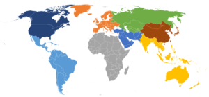
For the game I have organised the world in 8 areas, in alphabetical order: Africa, CIS (Russia), East Asia (with China), Europe, Latin America, Middle East (with the Arab peninsula), North America, South Asia (with India and Pacific).
In the below map, areas are very clearly visible
NB. I am also evaluating 12 areas, adding Central america, separating China and India. 12 is a better number because we can arrange 3,4,6 players very easily but this could be for future, maybe.
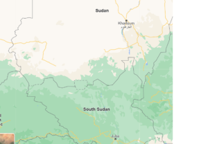
Did you know that in the true earth of Africa, between Sudan and South Sudan, there is an area that is not in any country?
=======================================
Previous version of this page can be found here